NASA links satellite data to monitor groundwater
US government space agency, NASA, has developed a new method for monitoring underground water loss.
To infinity and underground water
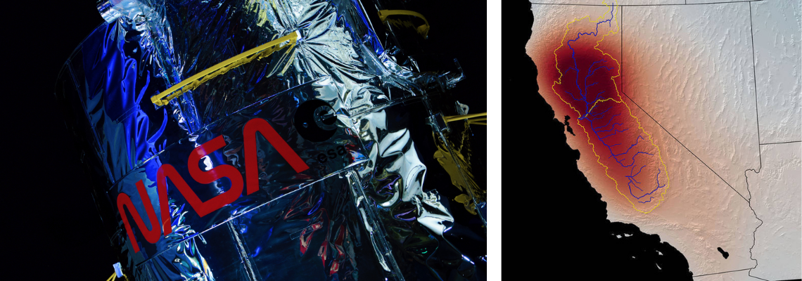
The National Aeronautics and Space Administration (NASA) has developed a method to monitor underground water loss that is showing promise following tests at California’s Tulare Basin.
The team studying the Tulare Basin, part of the Central Valley, found that the key to distinguishing between different underground sources of water relates to patterns of sinking and rising ground levels in this heavily irrigated agricultural region.
By using satellites, a research team from NASA’s Jet Propulsion Laboratory (JPL) and the U.S. Department of Energy’s Lawrence Berkeley Laboratory combined data on water loss from multiple sources.
This included the0. US European Gravity Recovery and Climate Experiment (GRACE) and GRACE Follow-On satellites with data on ground-level changes from an ESA (European Space Agency) Sentinel-1 satellite.
“The main question was, how do we interpret the change that’s happening on these shorter time scales: is it just a blip, or is it important?”
NASA scientists said the method can determine how much underground water loss comes from aquifers confined in clay, which can be drained so dry that they will not recover.
Furthermore, it can also determine how much comes from soil that’s not confined in an aquifer, which can be replenished by a few years of normal rains.
To infinity and underground
Ground-level changes are often related to water loss when the ground is drained of water causing it to slump together and sink into the spaces where water used to be, otherwise known as subsidence.
The Tulare Basin is subsiding drastically, and its current rate of subsidence is one foot (0.3 metres) of sinkage per year.
But what the team found was that from one month to the next, the ground could drop, rise and even stay the same. What’s more, these changes don’t always line up with expected causes.
For example, after heavy rainfall, the water table rises. It seems obvious that this would cause the ground level to rise, too, but sometimes the team tracked it sinking instead.
“The main question was, how do we interpret the change that’s happening on these shorter time scales: Is it just a blip, or is it important?” said Kyra Kim, a postdoctoral fellow at JPL and member of the research team.
So, what was causing this irregularity in subsidence?
It's what's underneath that counts
The research team concluded that the changes were related to the different kinds of soils in the basin.
Aquifers are confined by layers of stiff, impermeable clay, whereas unconfined soil is looser.
When water is pumped from an aquifer, the clay takes a while to compress in response to the weight of the landmass pressing down from above.
Unconfined soil, on the other hand, rises or falls more quickly in response to rain or pumping.
“Nasa says the model can be repurposed to represent other agricultural regions where groundwater use needs to be better monitored.”
Working on this theory, the team created a simple model using these two layers of soil.
By removing the long-term subsidence trend from the ground-level-change data, they produced a dataset of only the month-to-month variations.
The model revealed that on this time scale, almost all the ground-level change can be justified by the changes in aquifers, not in the water table.
Nasa says the model can be repurposed to represent other agricultural regions where groundwater use needs to be better monitored.
With a planned launch in 2023, the NASA-ISRO (Indian Space Research Organisation) Synthetic Aperture Radar (NISAR) mission will measure changes in ground level at an even higher resolution than Sentinel-1.
The consequences of pumping
It is no secret that underground water resources in the Tulare Basin are dwindling.
The Central Valley makes up only 1 per cent of US farmland but is responsible for 40 per cent of America's fruits, vegetables, and nuts annually.
As a result of this, it is only possible for farmers to augment the valley by five to ten inches of annual rainfall with extensive groundwater pumping.
“This could lead to more public drinking-water wells being shut down if costly treatment or cleaner water sources to mix with are not available.”
Groundwater pumping has become an over-relied upon resource in California as it battles some of the longest and toughest droughts the western state has ever seen.
During these long drought years, more than 80 per cent of irrigation water comes from underground resources.
The wells in this region are now being drilled as much as 3,500 feet, over 1,000 meters, deep to find adequate water that can be used for irrigation and drinking water.
Speaking about California's water challenges, Dr Zeno Levy, a research geologist with the United States Geological Survey (USGS) said: “Water quality problems from legacy groundwater pollution could get worse, faster when pumping increases during drought.
“This could lead to more public drinking-water wells being shut down if costly treatment or cleaner water sources to mix with are not available.”